Precisely aiding wildfire fight with risk assessment data
The data integrity vendor's specialized database includes added topographical and weather-related information to help organizations prepare for and predict catastrophic fires.
Precisely on Tuesday launched the latest version of Wildfire Risk, a database that helps users prepare for and prevent the spread of wildfires.
In addition to traditional wildfire risk assessment data such as terrain and climate, the database now includes Wildfire Risk Extreme data. It adds new layers to information about geographic characteristics such as temperature, humidity and wind speeds that affect the spread of fires, which can be particularly devastating in densely populated areas.
Precisely first made Wildfire Risk part of its portfolio following its 2021 acquisition of Anchor Point, a wildfire specialist providing data and modeling capabilities.
Justin Merino, managing director at the Morongo Basin Fire Safe Council in California's San Bernardino County, uses Wildfire Risk to assess the potential for wildfires in the Morongo Basin east of Los Angeles and works to prevent them from affecting local communities.
The council has been using Precisely's Wildfire Risk for just over a year, but has had access to much of the data within the database for about five years. Beyond using the data to inform decisions, the council has been able to use it to strengthen grant proposals requesting funds to pay for lifesaving safety measures.
"Wildfire Risk data has made our grant applications immeasurably stronger, which has allowed us to successfully secure grant allocations that provide the funds we need to save lives and protect our community from property damage and loss," Merino said. "The bottom line is, if we fail to secure a grant, that loss of funding could mean life or death for our citizens."
Wildfire Risk data has made our grant applications immeasurably stronger, which has allowed us to successfully secure grant allocations that provide the funds we need to save lives and protect our community from property damage and loss.
Justin MerinoManaging director, Morongo Basin Fire Safe Council
Based in Burlington, Mass., Precisely is a longtime data integrity specialist whose platform enables users to ensure data quality by keeping data accurate, consistent and contextual throughout its lifecycle. In addition to its primary platform, the vendor provides geospatial analytics tools and other specialized data products for the financial services, government, insurance, technology, retail and telecommunications industries.
Wildfire Risk is one such product, providing insurance companies, public sector organizations and telecommunications vendors with a specialized database.
New capabilities
In August 2023, a wildfire swept across the Hawaiian island of Maui, killing more than 100 people in Lahaina in the deadliest U.S. wildfire in more than a century and destroying much of the historic town. Currently, nearly 30 wildfires are raging in Oregon and Washington, where more than 500,000 people are under a fire danger warning, and more fires are burning in many parts of western Canada.
Overall, scientific research shows that the risk of extreme wildfires has doubled over the past 20 years. And to date in 2024, there have already been nearly 20,000 wildfires that have burned 2 million acres of land, according to Precisely.
The current wildfires and most of those to date this year largely affect land that is uninhabited by humans and where few human-made structures exist. However, as the wildfire in Hawaii showed, those that reach urban areas can have catastrophic effects.
To combat wildfires, Precisely developed Wildfire Risk using capabilities acquired through its purchase of Anchor Point.
Included in the tool is data that can affect the spread of wildfires such as terrain, slope of land, climate, vegetation, wind patterns, human activity, frequency of past fires, proximity to water and distance to fire stations. Wildfire Risk Extreme adds data about conditions during severe fire weather, looking at some of the same factors such as temperature and humidity to assess risk and enable communities to prepare during the times when fires are most likely to occur.
In particular, the new data aims to help municipalities and other organizations prepare for wildfires that could reach urban areas, according to Dan Adams, Precisely's senior vice president of data enrichment.
"These [added] factors are essential in predicting fast-spreading urban fires, also known as urban conflagrations," he said. "[Wildfire Risk Extreme] delivers actionable information for any location in the U.S. under extreme weather conditions."
That includes San Bernardino County's Morongo Basin, according to Merino.
"Being able to map wildfire risks and historical data and share that with our citizens has increased fire stewardship within the community and decreased the risk of wildfire damage," he said.
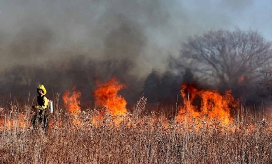
Data integrity vendor Precisely's Wildfire Risk database aims to help municipalities and other organizations better predict and prepare for wildfires.
In addition to public sector organizations that can use Wildfire Risk to help keep communities safe, the insurance and telecommunications industries are among those that stand to benefit most from wildfire risk assessment data, according to Precisely.
Telecommunications providers with cell towers, cable lines and phone lines across the landscape can use Wildfire Risk to understand more about the locations of their towers and power lines, including which are in high-risk locations. Insurers, meanwhile, can use the data to identify areas where wildfire risk has previously been underestimated to more accurately price policies and prepare for the likelihood of claims.
Precisely acquired Anchor Point and developed Wildfire Risk to provide customers with contextual data to assess wildfire risk, according to Adams. The vendor added Wildfire Risk Extreme, which was developed in concert with wildfire scientists and other experts in the field, in response to urban fires such as those in Lahaina and Boulder County, Colo., and with the understanding that such urban wildfires are becoming more common.
"The team understood that urban conflagrations in particular can represent unique challenges, requiring tailored solutions that go beyond traditional risk analysis and planning," Adams said.
Looking ahead
With Wildfire Risk Extreme now available, Precisely hopes to continue improving Wildfire Risk by providing real-time information, according to Adams. In addition, the vendor is looking at ways to combine Wildfire Risk with other data products in its data enrichment portfolio.
Should Precisely follow through on combining Wildfire Risk with other data products, it could be of benefit to organizations such as the Morongo Basin Fire Safe Council. The council does not currently use Precisely tools other than Wildfire Risk. However, it is looking into ways it could expand its use of Precisely to back up decisions throughout San Bernardino County.
"We're exploring how the Precisely data enrichment portfolio could help to inform and enrich policymaking across several additional parts of the county," Merino said.
Beyond data products that are largely made up of third-party data, Precisely's primary focus is on data integrity. Toward that end, the vendor's roadmap is focused on adding new APIs to help customers derive value from their own proprietary data, according to Adams.
"We will offer new APIs for querying our own data portfolio and enriching first-party data to reveal new insights about customer data that enable organizations to make confident decisions based on maximum data context," he said.
Eric Avidon is a senior news writer for TechTarget Editorial and a journalist with more than 25 years of experience. He covers analytics and data management.